One flight,
start to finish.
This page follows a single flight in order — from the moment you open the app on a patch of grass, through planning it, to standing there with your hands on the controller.
You open the app.
01
See the answer,
not the airspace.
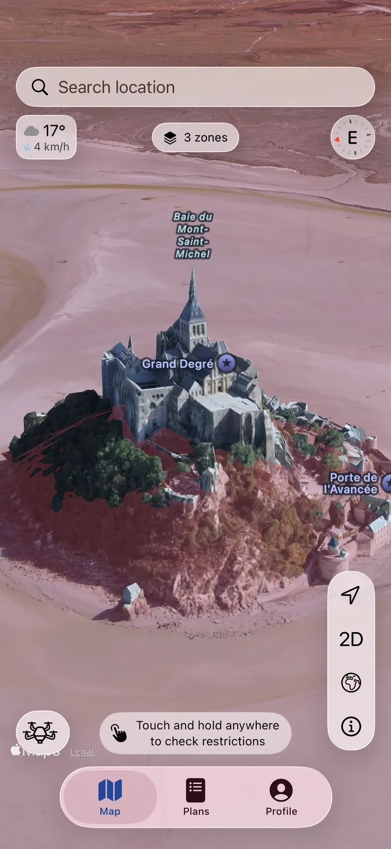
Every published zone around you, drawn in the colour of what it means for you — not which agency drew it. Green is flyable. Red is closed. Nothing to decode.
Zones carry their ceilings and floors, so a corridor that begins at 120 metres stops being your problem at 119.
02
Read the words
that decide it.
Open any zone and you get the authority’s own text and its own name — not our paraphrase. Where conditions attach, each one is listed separately, so you can see which you already meet.
Where the authority runs a portal or a form, the app carries the link. It points you at the right desk and stops there.
03
No data
never reads as clear.
Where we hold nothing for an area, the app shows it restricted — in the same red as a real prohibition, not a grey shrug. Every ambiguity resolves toward the restrictive answer.
A blank map that looks flyable is the most dangerous screen this app could draw. We never invent a restriction, and we never remove one.
You plan the flight.
04
Tell it which drone.
Pick the aircraft — down to a custom FPV build — and the map answers for that one. A zone whose requirement doesn’t bind your drone greys out instead of shouting.
Published specs only. Where a figure isn’t published, the app leaves it empty rather than guessing on your behalf.
05
How far can you get,
and still come home?
Range in the wind actually forecast at the height you fly — not a number off the box. Endurance is derated, a battery reserve is held back, and the outbound leg is committed in bands.
When it can’t be sure, it refuses rather than guesses: too windy, wind aloft unknown, cannot return.
06
Active now,
or not yet.
Air displays, state visits, wildfires, searches. Temporary restrictions read active in full purple and not currently active in a paler one — so a zone that isn’t biting today doesn’t look like one that is.
The published schedule is shown in full, in the authority’s own words. We print it rather than interpret it: reading a season’s exceptions for you is exactly the kind of guess this app refuses to make.
Save it as a plan
Date, place, duration, notes — and a whole fleet on one plan, each aircraft with its own range, its own weather and its own clearance state.
It lands in your calendar
A plan writes itself into your calendar through EventKit and stays linked to it, so the window you cleared is the window you turn up for.
You need it opened.
Some ground is flyable only if someone says so. The app gets you to the right desk with the right paperwork — and stops there.
The zone carries its contact
Where the authority publishes one, the number to call sits on the rule that says to call it — not three menus away in a PDF.
The dossier assembles itself
A zip with a cover letter naming the flight, the aircraft and the zone, plus exactly the documents that authority asks for — and the body to send it to, routed from the EASA IAM Hub.
Your documents, and their expiry
Operator registration, A1/A3, A2, LUC, insurance and ID — held in your own iCloud Drive, barcode readable on screen, with a reminder before each one lapses.
Where the answer is “we don’t know”
For six of thirty EASA states there is no published route. The app says unknown rather than inventing an address — a first-class answer, not a gap.
You fly.
Hands on the controller, phone in a pocket. Real screenshots from the watchOS app — the phone cuts a 50 km slice per country and sends it over, so a zone reaches the wrist with the same colour and the same rules it has on the phone.
Hazards that are not rules
Hospital helipads and the like are marked as hazards — real risks that carry no legal restriction, and are never dressed up as one.
Plans stay on your device
Flight plans are stored locally and never leave the phone. Not a marketing line — the store is configured with no cloud database at all.
Being built now
What’s next, and why.
The app is in beta, and you should see what you’re signing up to — not just what already works.
See the full roadmapThe launch wave
The European Economic Area, the UK, Australia, Canada and the United States — each from its own authority’s source.
A professional tier
For operators flying under authorisation, where the conditions matter more than the colours.
Try all of it, free.
The beta is open, with sixteen countries live and the launch wave on the way. It stays free for as long as the beta runs.